الوضع الليلي


 12:55:20
  2025-04-20
  2147
2147
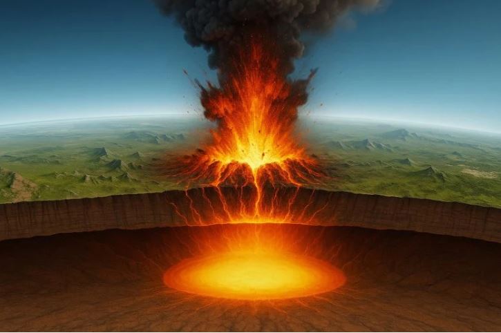
Researchers have identified a stable, gas-venting magma cap beneath Yellowstone, reducing eruption risk and advancing subsurface imaging techniques for broader geological applications.
Beneath the steaming geysers and bubbling mud pots of Yellowstone National Park lies one of the world’s most closely monitored volcanic systems. A recent study, published in Nature, offers new insights into how this powerful system functions and what may prevent it from erupting.
Researchers from Rice University, the University of New Mexico, the University of Utah, and the University of Texas at Dallas have identified a distinct, volatile-rich magma layer just 3.8 kilometers below Yellowstone’s surface. This layer acts as a cap, effectively trapping heat and pressure beneath it. Using advanced controlled-source seismic imaging and high-resolution computer modeling, the team found that the magma reservoir is actively releasing gases while remaining stable.
The study, led by Chenglong Duan and Brandon Schmandt of Rice University, sheds new light on the movement of magma, gases, and fluids within Earth’s crust. The research was supported by the National Science Foundation.
“For decades, we’ve known there’s magma beneath Yellowstone, but the exact depth and structure of its upper boundary has been a big question,” said Schmandt, professor of Earth, environmental, and planetary sciences. “What we’ve found is that this reservoir hasn’t shut down — it’s been sitting there for a couple million years, but it’s still dynamic.”
Previous studies suggested the top of Yellowstone’s magma system could lie anywhere from 3 to 8 kilometers deep — an uncertainty that left geologists debating how the magma system today compares with conditions before prior eruptions.
Seismic Imaging Brings New Clarity
That changed after Schmandt conducted a high-resolution seismic survey in the northeastern part of the caldera. A 53,000-pound vibroseis truck — typically used for oil and gas exploration — essentially generated tiny earthquakes to send seismic waves into the ground. These waves reflected off subsurface layers and were recorded at the surface, revealing a sharp boundary at about 3.8 km depth.
“The motivation behind my research is to advance structural seismic imaging beyond the limits of conventional travel-time methods,” said Duan, a postdoctoral research associate. “Using a wave-equation imaging technique I developed during my Ph.D. for irregular seismic data, we made one of the first super clear images of the top of the magma reservoir beneath Yellowstone caldera.”
“Seeing such a strong reflector at that depth was a surprise,” Schmandt said. “It tells us that something physically distinct is happening there — likely a buildup of partially molten rock interspersed with gas bubbles.”
To better understand what causes this signal, Duan and Schmandt modeled various rock, melt, and volatile combinations. The best match they determined is a mixture of silicate melt and supercritical water bubbles within a porous rock matrix resulting in a volatile-rich cap with about 14% porosity, half of which is occupied by fluid bubbles.
As magma rises and decompresses in volcanic systems, gases like water and carbon dioxide exsolve from the melt, forming bubbles. In some cases, these bubbles can accumulate, increasing buoyancy and potentially driving explosive eruptions.
But present conditions at Yellowstone appear to tell a different story.
“Although we detected a volatile-rich layer, its bubble and melt contents are below the levels typically associated with imminent eruption,” Schmandt said. “Instead, it looks like the system is efficiently venting gas through cracks and channels between mineral crystals, which makes sense to me given Yellowstone’s abundant hydrothermal features emitting magmatic gases.”
Schmandt likened the system to “steady breathing” with bubbles rising and releasing through the porous rock — a natural pressure-release valve that lowers eruption risk.
Challenges in the Field and Data Lab
Getting these results was anything but easy. The research team not only completed the field survey in the midst of the COVID-19 pandemic, but they also had to coordinate the project within a busy and carefully protected national park. This meant they could only operate the heavy vibroseis truck at night and only from designated roadside turnouts. More than 600 seismometers were temporarily deployed to record the vibroseis truck signals, then recovered a few weeks later. Collaboration with University of Utah professor Jamie Farrell, a Yellowstone geophysics expert and seismic network operator, was essential to making this unusual survey possible, Schmandt said.
Processing the data proved just as difficult. Yellowstone’s complex geology — known for scattering seismic waves — produced noisy data that were initially hard to interpret. But with persistence and many discussions with Schmandt, Duan said he kept going, refining his approach again and again until the numbers finally told a clear story.
“The challenge was that the raw data made it almost impossible to visualize any reflection signals,” Duan said. “We used the STA/LTA function to enhance coherent seismic reflections, and this was the first time we had innovatively applied STA/LTA data within the wave-equation imaging algorithm.”
Duan said that just like traversing the rocky landscape of Yellowstone, tenacity is key for navigating its mysteries underground.
“When you see noisy, challenging data, don’t give up,” Duan said. “After we realized the standard processing was not going to work, that’s when we got creative and adapted our approach.”
By identifying this sharp, volatile-rich cap beneath Yellowstone, Schmandt’s team has established a new benchmark for monitoring the volcano’s activity. Future research could attempt to detect any shifts in melt content or gas accumulation that may serve as early warning signs of unrest.
Beyond Yellowstone, the study offers broader insights into onshore subsurface imaging with potential applications not only for volcano monitoring but also for carbon storage, energy exploration and hazard assessment.
“Being able to image what’s happening underground is important for everything from geothermal energy to storing carbon dioxide,” Schmandt said. “This work shows that with creativity and perseverance, we can see through complicated data and reveal what’s happening beneath our feet.”
Reality Of Islam |
|

NASA’
Mass spectr

As space ex
Researchers
 9:3:43
2018-11-05
9:3:43
2018-11-05
10 benefits of Marriage in Islam
7:5:22
2019-04-08
benefits of reciting surat yunus, hud &
9:45:7
2018-12-24
advantages & disadvantages of divorce
11:35:12
2018-06-10
6:0:51
2018-10-16
11:34:48
2022-06-29
7:59:14
2018-06-21
8:4:21
2022-01-08
a hero waters thirsty wild animals
9:4:9
2022-01-06
2:42:26
2023-02-02
2:34:48
2022-01-18
6:14:3
2023-01-18
5:41:46
2023-03-18
| LATEST |
 HOME
HOME